

Notes based on the chapter ‘Climate’ of NCERT Class 9 Geography Textbook: The notes given here cover almost all relevant topics under headings points. Click here for more study materials on class 9 SST.
Climate and Weather
Definition
- Climate: Sum total of weather conditions and variations over a large area for more than thirty years.
- Weather: State of the atmosphere over an area at any point in time.
Elements of Weather and Climate
- Common elements: temperature, atmospheric pressure, wind, humidity, and precipitation.
- Weather conditions fluctuate frequently within a day, but there is a common pattern over weeks or months.
- Year divided into seasons based on generalized monthly atmospheric conditions (winter, summer, rainy).
Climatic Regions
- The world is divided into various climatic regions.
- India’s climate is of the ‘monsoon’ type, mainly in the south and southeast.
- Regional variations exist despite an overall unity in the general pattern.
Regional Variations in India
Temperature
- Summer: Rajasthan desert may reach 50°C, while Pahalgam in Jammu and Kashmir may be around 20°C.
- Winter: Drass in Jammu and Kashmir can drop to minus 45°C, while Thiruvananthapuram may have 22°C.
Precipitation
- Various forms and types of precipitation with differences in amount and seasonal distribution.
- Snowfall in the upper Himalayas, while the rest of the country experiences rainfall.
- Annual precipitation ranges from over 400 cm in Meghalaya to less than 10 cm in Ladakh and western Rajasthan.
- Rainfall mostly from June to September, but Tamil Nadu coast receives a significant portion in October and November.
Regional Climate Characteristics
- Coastal areas experience less temperature contrast; seasonal contrasts are more pronounced in the interior.
- Decrease in rainfall generally from east to west in the Northern Plains.
- Climate variations influence people’s lives, affecting their food, clothing, and housing choices.
Climatic Controls
1. Latitude
- Definition: Due to the curvature of the earth, the amount of solar energy received varies according to latitude.
- Effect: Air temperature generally decreases from the equator towards the poles.
2. Altitude
- Effect: As one ascends from the surface of the earth to higher altitudes, the atmosphere becomes less dense, and temperature decreases.
- Example: Hills are cooler during summers due to increased altitude.
3. Pressure and Wind System
- Influence: Latitude and altitude determine the pressure and wind system of an area.
- Impact: Significant influence on temperature and rainfall patterns.
4. Distance from the Sea (Continentality)
- Definition: Sea exerts a moderating influence on climate.
- Effect: Increased distance from the sea leads to decreased moderating influence, resulting in extreme weather conditions.
- Condition: Known as continentality, characterized by very hot summers and very cold winters.
5. Ocean Currents
- Influence: Ocean currents, along with onshore winds, affect the climate of coastal areas.
- Example: Coastal areas with warm or cold currents experience warming or cooling based on onshore winds.
6. Relief Features
- Role: Relief features play a major role in determining climate.
- Mountains: Act as barriers for cold or hot winds and may cause precipitation if high enough and in the path of rain-bearing winds.
- Leeward Side: The leeward side of mountains remains relatively dry.
Summary Points
- Climate is influenced by six major controls: latitude, altitude, pressure and wind system, distance from the sea, ocean currents, and relief features.
- These controls collectively shape temperature and precipitation patterns, as well as the overall climate of a region.
Factors Affecting India’s Climate
1. Latitude
- Position: Tropic of Cancer passes through the middle of India from Rann of Kuchchh in the west to Mizoram in the east.
- Impact: Almost half of India, south of Tropic of Cancer, belongs to the tropical area, while the remaining northern region lies in the subtropics.
- Result: India experiences characteristics of both tropical and subtropical climates.
2. Altitude
- Geography: Northern mountains in India have an average height of about 6,000 meters, while the coastal areas have a maximum elevation of around 30 meters.
- Influence: Himalayas act as a barrier, preventing cold winds from Central Asia, leading to milder winters in the subcontinent.
3. Pressure and Winds in India
1. Atmospheric Conditions
Climate and weather conditions in India are influenced by three main atmospheric factors:
- Pressure and surface winds
- Upper air circulation
- Western cyclonic disturbances and tropical cyclones
2. Pressure and Surface Winds
- India lies in the region of north easterly winds.
- Origin: These winds originate from the subtropical high-pressure belt of the northern hemisphere.
- Movement: They blow southwards, get deflected to the right due to the Coriolis force, and move towards the equatorial low-pressure area.
- Moisture Content: Generally, these winds carry little moisture as they originate and blow over land, resulting in little or no rain.
3. Unique Wind Conditions in India
- Winter: High-pressure area north of the Himalayas causes cold dry winds to blow towards low-pressure areas over the oceans in the south.
- Summer: Low-pressure area over interior Asia and northwestern India leads to a reversal of wind direction. Southwest Monsoon winds develop, moving from the southern Indian Ocean, crossing the equator, and turning right towards the low-pressure areas over the Indian subcontinent.
- Monsoon Characteristics: These Southwest Monsoon winds blow over warm oceans, gather moisture, and bring widespread rainfall over mainland India.
Unusual Moisture Source
- Despite originating over land, the Southwest Monsoon winds become a crucial source of moisture due to their trajectory over warm oceans.
- This unique combination of pressure and wind conditions prevents India from being an arid land, contributing to the country’s diverse climate and rainfall patterns.
Summary Points
- India’s climate is influenced by factors such as latitude, altitude, and pressure and wind conditions.
- The geography, including the Himalayas and coastal areas, plays a crucial role in shaping the climate of the subcontinent.
- North easterly winds, the development of Southwest Monsoon winds, and the unique interplay of high and low-pressure areas contribute to the diverse weather patterns and rainfall in different seasons.
- The monsoon winds, especially the Southwest Monsoon, are a significant determinant of India’s seasonal rainfall patterns.
The Seasons in India
Monsoon Type of Climate
Characteristics:
- Distinct seasonal pattern with significant changes in weather conditions.
- More noticeable in the interior parts of the country.
- Coastal areas experience less temperature variation but show variation in rainfall patterns.
Four Main Seasons in India
1. Cold Weather Season:
- Time: Typically occurs during winter.
- Characteristics: Cooler temperatures prevail.
2. Hot Weather Season:
- Time: Typically occurs during summer.
- Characteristics: Elevated temperatures with heat dominating.
3. Advancing Monsoon:
- Time: Marks the onset of the monsoon season.
- Characteristics: Arrival of monsoon winds bringing widespread rainfall.
- Impact: Essential for agriculture and replenishing water resources.
4. Retreating Monsoon:
- Time: Marks the withdrawal of monsoon winds.
- Characteristics: Decrease in rainfall, transitioning towards drier conditions.
- Impact: Signifies the end of the monsoon season.
Regional Variations
Coastal Areas:
- Experience less temperature variation.
- Show variation in rainfall patterns.
Summary Points
- India’s monsoon type of climate exhibits distinct seasonal patterns, particularly noticeable in the interior.
- Four main seasons in India include the cold weather season, hot weather season, advancing monsoon, and retreating monsoon, each with specific characteristics.
- Coastal areas experience less temperature variation but exhibit variations in rainfall patterns.
- These seasons play a crucial role in shaping the country’s agricultural practices and overall lifestyle.
The Cold Weather Season (Winter)
Duration
- Time Period: From mid-November to February.
- Coldest Months: December and January in northern India.
Temperature Variation
- North-South Gradient:
- Temperature decreases from south to north.
- Average temperature in Chennai (eastern coast): 24°–25°C.
- In northern plains: Ranges between 10°C and 15°C.
- Day-Night Contrast:
- Days are warm, while nights are cold.
- Frost common in the north; higher slopes of the Himalayas experience snowfall.
Wind Patterns
- Northeast Trade Winds:
- Prevail over the country.
- Blow from land to sea, resulting in a dry season for most parts.
- Some rainfall on the Tamil Nadu coast as winds blow from sea to land.
Atmospheric Conditions
- High-Pressure Region:
- Develops in the northern part of the country.
- Light winds move outward, influenced by the relief.
- Ganga valley experiences winds from the west and northwest.
- Weather marked by clear skies, low temperatures, low humidity, and feeble, variable winds.
Cyclonic Disturbances
- Origin and Impact:
- Cyclonic disturbances from the west and northwest.
- Originate over the Mediterranean Sea and western Asia.
- Cause winter rains over the plains and snowfall in the mountains.
- Known as ‘mahawat,’ these rains are crucial for cultivating ‘rabi’ crops.
Peninsular Region
- Characteristics:
- Lacks a well-defined cold season.
- Minimal seasonal change in temperature during winters.
- Moderating influence of the sea prevents extreme variations.
Summary Points
- The cold weather season in India spans from mid-November to February, with December and January being the coldest months in the northern part of the country.
- Temperature variations, wind patterns, and atmospheric conditions contribute to the distinct features of this season.
- Cyclonic disturbances from the west and northwest bring winter rains crucial for ‘rabi’ crop cultivation.
- The peninsular region experiences milder winters with less noticeable seasonal temperature changes due to the moderating influence of the sea.
The Hot Weather Season (Summer)
Duration and Cause
- Time Period: From March to May.
- Cause: Apparent northward movement of the sun, leading to the northward shift of the global heat belt.
Temperature Variations
- March to May:
- Deccan Plateau (March): Highest temperature around 38°C.
- Gujarat and Madhya Pradesh (April): Temperatures around 42°C.
- Northwestern Parts (May): Common temperature of 45°C.
- Peninsular India: Moderated temperatures due to the influence of oceans.
Atmospheric Conditions
- Temperature and Air Pressure:
- Rising temperatures and falling air pressure in the northern part of the country.
- Elongated low-pressure area develops from Thar Desert to Patna and Chotanagpur plateau by the end of May.
- Air circulation sets in around this trough.
Weather Phenomena
- Loo:
- Characteristics: Strong, gusty, hot, dry winds during the day in north and northwestern India.
- Impact: Can be fatal; dust storms are common in May, providing temporary relief and lower temperatures.
- Thunderstorms:
- Localized Thunderstorms: Associated with violent winds, torrential downpours, and hail.
- West Bengal: Known as ‘Kaal Baisakhi.’
Pre-Monsoon Showers
- Occurrence: Towards the close of the summer season.
- Regions: Common, especially in Kerala and Karnataka.
- Purpose: Aids in the early ripening of mangoes, often referred to as ‘mango showers.’
Summary Points
- The hot weather season in India occurs from March to May due to the northward movement of the sun.
- Temperature variations are observed across different regions, with the influence of oceans moderating temperatures in peninsular India.
- Atmospheric conditions include rising temperatures, falling air pressure, and the development of a low-pressure area by the end of May.
- Unique weather phenomena such as the ‘loo,’ dust storms, thunderstorms, and pre-monsoon showers characterize the hot weather season.
Advancing Monsoon (The Rainy Season)
Onset and Origin
- Timing: Early June.
- Condition: Intensification of the low-pressure system over the northern plains.
- Trade Winds: Attracts southeast trade winds from the southern hemisphere.
South-West Monsoon
- Origin: Southeast trade winds cross the equator, blow in a southwesterly direction, entering the Indian peninsula as the south-west monsoon.
- Moisture Source: Originating over warm subtropical areas of the southern oceans, bringing abundant moisture.
Characteristics
- Wind Speed: Strong winds with an average velocity of 30 km per hour.
- Coverage: Covers the entire country (except extreme northwest) in about a month.
Rainfall Distribution
Early Season Patterns:
- Western Ghats’ windward side receives heavy rainfall (over 250 cm).
- Deccan Plateau and parts of Madhya Pradesh receive some rain despite being in the rain shadow area.
- Maximum rainfall in the northeastern part of the country.
- Mawsynram in the Khasi Hills receives the world’s highest average rainfall.
- Ganga valley experiences decreasing rainfall from east to west.
- Rajasthan and parts of Gujarat receive scanty rainfall.
Monsoon Breaks
- Phenomenon: ‘Breaks’ or intervals in rainfall with wet and dry spells.
- Causes: Related to the movement of the monsoon trough.
- Spatial Impact: Trough axis movements determine the spatial distribution of rainfall.
- Consequences: Longer dry spells in plains when the trough axis shifts closer to the Himalayas, causing widespread rain in mountainous catchment areas.
Tropical Depressions
- Formation: At the head of the Bay of Bengal, crossing over to the mainland.
- Path: Follow the axis of the “monsoon trough of low pressure.”
- Impact: Influence the amount and duration of monsoon rains; contribute to floods.
Monsoon Uncertainties
Characteristics:
- Alternation of dry and wet spells with varying intensity, frequency, and duration.
- Irregular arrival and retreat, disturbing farming schedules.
- Causes heavy floods in some regions and droughts in others.
- Intensity and duration influenced by tropical depressions.
Summary Points
- The advancing monsoon, beginning in early June, is characterized by the intensification of the low-pressure system and the influx of southeast trade winds.
- The south-west monsoon covers the entire country, bringing abundant moisture and resulting in distinctive rainfall patterns.
- Rainfall distribution varies across regions, with the onset of wet and dry spells associated with the movement of the monsoon trough.
- Tropical depressions play a crucial role in determining the intensity and duration of monsoon rains, contributing to floods and uncertainties in farming schedules.
Retreating/Post Monsoons (The Transition Season)
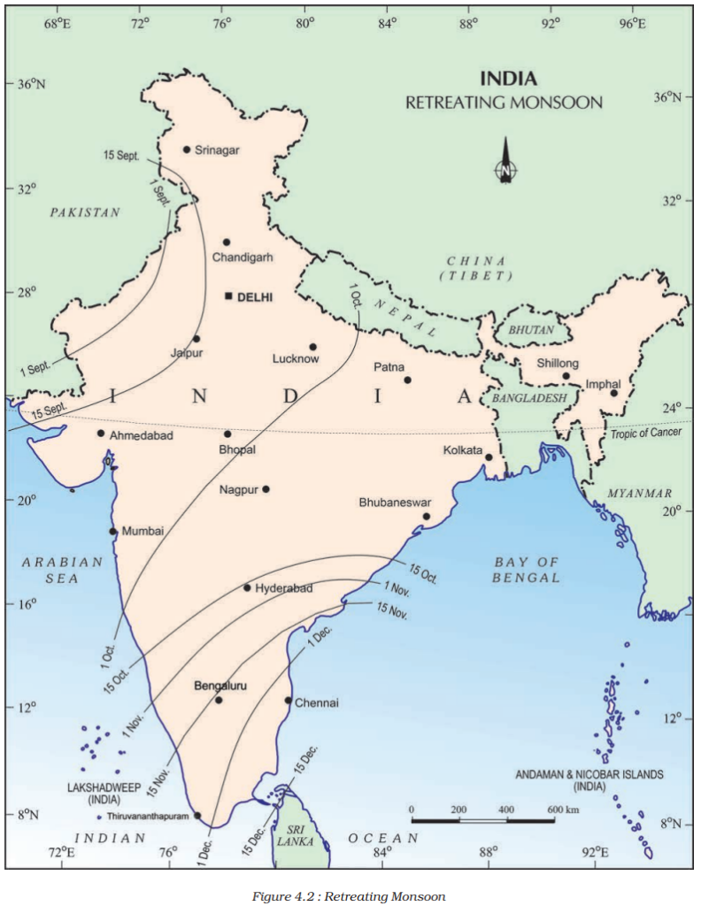
Timing and Transition
- Timing: October-November.
- Transition: Apparent movement of the sun towards the south weakens the monsoon trough or low-pressure trough over the northern plains.
Atmospheric Changes
- High-Pressure System: Gradual replacement of the low-pressure system.
- Weakening Monsoon Winds: South-west monsoon winds gradually withdraw.
- Withdrawal Timeline: Begins in October, withdrawing from the Northern Plains.
Transition Period Characteristics
- Weather Shift: Transition from hot rainy season to dry winter conditions.
- Retreat Markers:
- Clear skies and rising temperatures.
- High day temperatures, cool and pleasant nights.
- Moist land conditions persist.
- Oppressive weather during the day, known as ‘October heat.’
Rapid Cooling in Northern India
- October Second Half: Mercury begins to fall rapidly.
- Shift of Low-Pressure Conditions: Transfer from northwestern India to the Bay of Bengal by early November.
Cyclonic Depressions
- Origin: Cyclonic depressions originate over the Andaman Sea.
- Impact: Cross the eastern coasts of India, causing heavy and widespread rain.
- Destructive Nature: Cyclones are often destructive, particularly in densely populated deltas like Godavari, Krishna, and Kaveri.
- Affected Regions: Coasts of Odisha, West Bengal, and Bangladesh may also be impacted.
Coromandel Coast Rainfall
- Derivation: Bulk of rainfall on the Coromandel Coast comes from depressions and cyclones.
Summary Points
- The retreating or post-monsoon season occurs during October-November.
- Atmospheric changes include the weakening of the monsoon trough and the gradual replacement by a high-pressure system.
- The transition period is characterized by clear skies, rising temperatures, and a shift from hot, rainy weather to dry winter conditions.
- Cyclonic depressions originating in the Andaman Sea impact eastern coasts, causing heavy rainfall and potential destruction in densely populated deltas and other coastal areas.
- The Coromandel Coast receives a significant portion of its rainfall from depressions and cyclones during this period.
Distribution of Rainfall in India
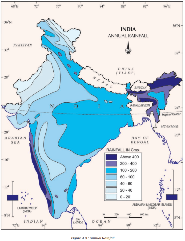
Regions with High Rainfall
Western Coast and Northeastern India:
- Annual Rainfall: Over 400 cm.
- Reason: Proximity to the Arabian Sea and Bay of Bengal, which bring moisture-laden winds during the monsoon.
Regions with Low Rainfall
- Western Rajasthan and Adjoining Parts of Gujarat, Haryana, and Punjab:
- Annual Rainfall: Less than 60 cm.
- Reason: Located in the rain shadow area, receiving limited moisture due to obstruction by the Aravalli Range and prevailing wind patterns.
- Interior of the Deccan Plateau and East of the Sahyadris:
- Annual Rainfall: Low.
- Reason: Rain shadow effect from the Western Ghats, hindering the penetration of moisture-laden winds.
- Leh in Jammu and Kashmir:
- Annual Rainfall: Low.
- Reason: High altitude and geographical location, limiting moisture availability.
Regions with Moderate Rainfall
Rest of the Country:
- Annual Rainfall: Moderate.
- Reason: Varied, influenced by monsoon winds, topography, and geographical features.
Snowfall
Himalayan Region:
- Snowfall: Restricted to the Himalayan region.
- Reason: High altitude and colder temperatures.
Variability and Consequences
- Monsoon Nature: Annual rainfall highly variable from year to year due to the nature of monsoons.
- Regions of High Variability: Parts of Rajasthan, Gujarat, and the leeward side of the Western Ghats.
- Consequences:
- Areas of high rainfall prone to floods.
- Areas of low rainfall prone to droughts.
Summary Points
- Regions with high rainfall are along the western coast and northeastern India, receiving over 400 cm annually.
- Regions with low rainfall include western Rajasthan, parts of Gujarat, Haryana, Punjab, the interior of the Deccan Plateau, east of the Sahyadris, and Leh in Jammu and Kashmir.
- Moderate rainfall is observed in the rest of the country, influenced by various factors.
- The variability in annual rainfall is high, leading to floods in areas with high rainfall and droughts in areas with low rainfall.
Monsoon as a Unifying Bond in India
Himalayan Protection from Cold Winds:
- Himalayas protect the subcontinent from extremely cold winds from Central Asia.
- Enables northern India to have uniformly higher temperatures compared to areas on the same latitudes.
Peninsular Plateau Influence
Moderate Temperatures: Peninsular plateau, surrounded by the sea from three sides, experiences moderate temperatures.
Unifying Influence of the Monsoon
- Seasonal Alteration: Monsoon brings rhythmic cycles of seasons through seasonal alteration of wind systems and associated weather conditions.
- Perceptible Influence: Despite temperature variations, the unifying influence of the monsoon is perceptible.
- Typical Monsoon Characteristics: Uncertainties in rain and uneven distribution are typical features of the monsoons.
- Yearly Expectation: People eagerly await the arrival of the monsoon year after year.
- Binding the Country: Monsoon winds bind the entire country by providing water for agricultural activities.
- River Valleys: The river valleys, carrying monsoon water, unite as a single river valley unit.
Impact on Indian Life
- Agricultural Calendar: Monsoons play a crucial role in shaping the agricultural calendar.
- Landscape, Flora, and Fauna: The Indian landscape, as well as its flora and fauna, are deeply influenced by the monsoons.
- Cultural Significance: Festivals, traditions, and daily life of the people revolve around the monsoon phenomenon.
Summary Points
- The Himalayas shield the subcontinent, allowing northern India to maintain uniformly higher temperatures.
- The Peninsular Plateau, surrounded by the sea, experiences moderated temperatures but still exhibits variations.
- The monsoon acts as a unifying force, bringing rhythmic cycles of seasons and influencing the entire landscape, agriculture, and cultural aspects of Indian life.
- The anticipation and arrival of the monsoon are eagerly awaited, binding the country together through agricultural activities and the unification of river valleys.
Do You Know?
- The word monsoon is derived from the Arabic word ‘mausim’ which literally means season. • ‘Monsoon’ refers to the seasonal reversal in the wind direction during a year
- In certain places there is a wide difference between day and night temperatures. In the Thar Desert the day temperature may rise to 50°C, and drop down to near 15°C the same night. On the other hand, there is hardly any difference in day and night temperatures in the Andaman and Nicobar islands or in Kerala.
- Mawsynram, the wettest place on the earth is also reputed for its stalagmite and stalactite caves.
- Coriolis force: An apparent force caused by the earth’s rotation. The Coriolis force is responsible for deflecting winds towards the right in the northern hemisphere and towards the left in the southern hemisphere. This is also known as ‘Ferrel’s Law’.