

Notes of the Chapter 3 ‘Drainage’ Class 9 NCERT Geography: The notes are well drafted under proper headings and key points based on the NCERT Geography textbook for class 9. Click here for notes of other class 9 geography chapter .
Drainage Systems
Drainage systems are a crucial aspect of the Earth’s hydrological cycle and play a vital role in the distribution of water resources. Understanding drainage patterns is important for various environmental and geographical studies.
Definition of Drainage: The term drainage refers to the river system of an area.
Components of Drainage:
- Small streams from different directions converge to form the main river.
- The main river eventually drains into a large water body like a lake, sea, or ocean.
Drainage Basin:
- The area drained by a single river system is known as a drainage basin.
- Each river system has its own unique drainage basin.
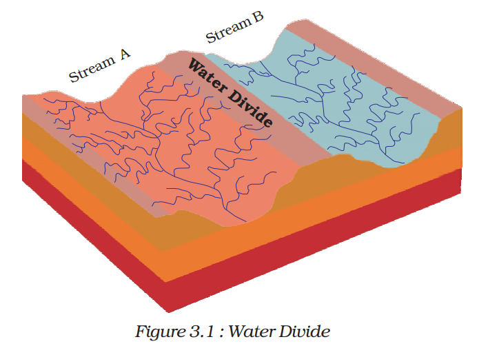
Water Divide:
- An elevated area, such as a mountain or upland, separates two drainage basins.
- This elevated area is referred to as a water divide.
- Figure 3.1 provides a visual representation of a water divide in a drainage system.
Summary:
- Drainage systems involve the convergence of small streams to form larger rivers that ultimately drain into large bodies of water.
- Each river system has its own drainage basin.
- Elevated areas like mountains act as water divides, separating different drainage basins.
Drainage Systems in India
Classification of Indian Rivers:
- The drainage systems of India are primarily influenced by the country’s topographical features.
- Indian rivers can be broadly categorized into two major groups:
- Himalayan rivers
- Peninsular rivers
Himalayan Rivers:
- Most Himalayan rivers are perennial, meaning they have water throughout the year.
- They receive water from both rainfall and the melting snow from the lofty mountains.
- Notable examples include the Indus and the Brahmaputra, which originate from the northern regions of the mountains.
- These rivers have cut through the mountains, forming gorges.
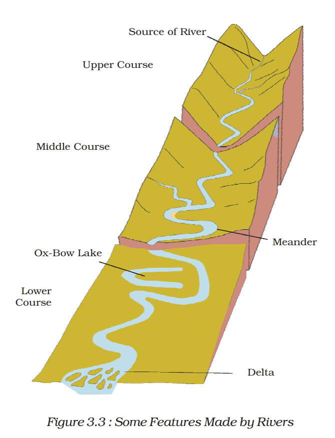
- In their upper courses, Himalayan rivers carry substantial loads of silt and sand due to intensive erosional activity.
- As they flow downstream, they create features like meanders, oxbow lakes, and various depositional features in their floodplains.
- They also develop well-defined deltas (see Figure 3.3).
Peninsular Rivers:
- Many of the Peninsular rivers are seasonal, with their flow dependent on rainfall.
- During the dry season, even large Peninsular rivers have reduced water flow in their channels.
- These rivers typically have shorter and shallower courses compared to their Himalayan counterparts.
- Some Peninsular rivers originate in the central highlands and flow westward.
- Two such large rivers are yet to be identified.
- Most Peninsular rivers originate in the Western Ghats and flow eastward towards the Bay of Bengal.
Summary:
- India’s drainage systems are primarily influenced by its topography.
- The country’s rivers are classified into Himalayan and Peninsular rivers.
- Himalayan rivers are perennial, originating from mountain regions and creating erosional and depositional features along their courses.
- Peninsular rivers, often seasonal, flow through shorter courses and mainly originate in the Western Ghats, flowing towards the Bay of Bengal.
Himalayan Rivers of India
Indus River System:
- The Indus River originates in Tibet near Lake Mansarowar.
- It enters India in Ladakh, forming a picturesque gorge.
- Several tributaries, including Zaskar, Nubra, Shyok, and Hunza, join it in the Kashmir region.
- The Indus flows through Baltistan and Gilgit before emerging from the mountains at Attock.
- Major tributaries like Satluj, Beas, Ravi, Chenab, and Jhelum converge near Mithankot in Pakistan.
- It flows southward, eventually reaching the Arabian Sea east of Karachi.
- The Indus basin spans India (Ladakh, Jammu and Kashmir, Himachal Pradesh, and Punjab) and Pakistan.
Ganga River System:
- The Ganga’s headwaters, known as the Bhagirathi, are fed by the Gangotri Glacier.
- It merges with the Alaknanda at Devaprayag in Uttarakhand.
- At Haridwar, the Ganga emerges onto the plains.
- Several major tributaries, including Yamuna, Ghaghara, Gandak, and Kosi, join the Ganga from the Himalayas.
- Yamuna rises from the Yamunotri Glacier and meets the Ganga at Allahabad.
- Tributaries from peninsular uplands include Chambal, Betwa, and Son.
- The Ganga bifurcates at Farakka in West Bengal, with Bhagirathi-Hooghly flowing southward and the mainstream entering Bangladesh.
- In Bangladesh, it combines with the Brahmaputra, becoming the Meghna, and flows into the Bay of Bengal.
- The Ganga delta formed by these rivers is known as the Sundarbans Delta.
- The Ganga’s total length is over 2500 km.
Brahmaputra River System:
- The Brahmaputra originates in Tibet near the sources of the Indus and Satluj.
- It flows eastward parallel to the Himalayas before turning southward near Namcha Barwa (7757 m).
- Entering India in Arunachal Pradesh through a gorge, it is called the Dihang.
- Tributaries like Dibang and Lohit join it to form the Brahmaputra in Assam.
- Tibet’s Brahmaputra carries less water and silt due to its cold and dry climate.
- In India, the river collects significant water and silt due to high rainfall.
- The Brahmaputra features a braided channel in Assam and forms numerous riverine islands.
- The world’s largest riverine island formed by the Brahmaputra is not specified.
- Annual rainy season floods cause widespread devastation in Assam and Bangladesh.
- Unlike other north Indian rivers, the Brahmaputra accumulates substantial silt deposits, causing its riverbed to rise and frequent channel shifts.
Drainage Pattern:
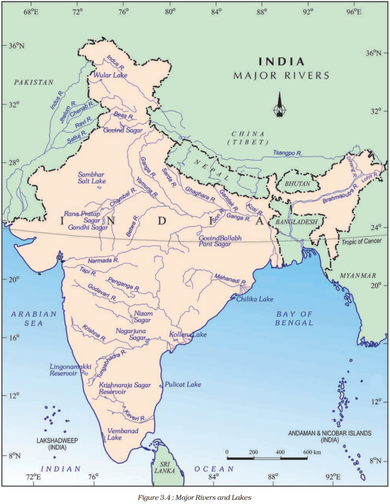
- The Ganga river system exhibits a dendritic drainage pattern, as seen in Figure 3.4.
- Ambala is situated on the water divide between the Indus and Ganga river systems.
- The plains stretching from Ambala to the Sundarbans cover nearly 1800 km but have a slight slope, resulting in large meanders in the rivers.
Peninsular Rivers of India
Water Divide in Peninsular India:
- The Western Ghats, running from north to south along the western coast, form the main water divide in Peninsular India.
- Most major Peninsular rivers, such as the Mahanadi, Godavari, Krishna, and Kaveri, flow eastward and drain into the Bay of Bengal, forming deltas at their mouths.
- Some smaller streams flow west of the Western Ghats.
- The Narmada and the Tapi are the only long rivers flowing westward, forming estuaries.
The Narmada Basin:
- The Narmada River originates in the Amarkantak hills in Madhya Pradesh.
- It flows westward in a rift valley formed due to faulting.
- Along its course, the Narmada creates picturesque locations like the ‘Marble rocks’ near Jabalpur and the ‘Dhuadhar falls.’
- The Narmada basin covers parts of Madhya Pradesh and Gujarat.
- Tributaries of the Narmada are short and join the main stream at right angles.
The Tapi Basin:
- The Tapi River rises in the Satpura ranges, Betul district, Madhya Pradesh.
- It flows in a rift valley parallel to the Narmada but is shorter in length.
- The Tapi basin covers parts of Madhya Pradesh, Gujarat, and Maharashtra.
West Flowing Rivers:
- The coastal plains between the Western Ghats and the Arabian Sea are narrow, resulting in short west-flowing rivers.
- Notable west-flowing rivers include Sabarmati, Mahi, Bharathpuzha, and Periyar, among others.
The Godavari Basin:
- The Godavari is the largest Peninsular river, rising from the slopes of the Western Ghats in Nasik district, Maharashtra.
- It has a length of about 1500 km and drains into the Bay of Bengal.
- The Godavari basin covers parts of Maharashtra, Madhya Pradesh, Odisha, and Andhra Pradesh.
- Major tributaries include Purna, Wardha, Pranhita, Manjra, Wainganga, and Penganga.
- Due to its length and coverage area, it is known as the Dakshin Ganga.
The Mahanadi Basin:
- The Mahanadi rises in the highlands of Chhattisgarh and flows through Odisha to reach the Bay of Bengal.
- Its length is approximately 860 km, and its drainage basin is shared by Maharashtra, Chhattisgarh, Jharkhand, and Odisha.
The Krishna Basin:
- The Krishna River originates near Mahabaleshwar and flows for about 1400 km before reaching the Bay of Bengal.
- Major tributaries include Tungabhadra, Koyana, Ghatprabha, Musi, and Bhima.
- Its drainage basin is shared by Maharashtra, Karnataka, and Andhra Pradesh.
The Kaveri Basin:
- The Kaveri River rises in the Western Ghats’ Brahmagri range and flows into the Bay of Bengal south of Cuddalore, Tamil Nadu.
- It has a total length of about 760 km and is joined by main tributaries like Amravati, Bhavani, Hemavati, and Kabini.
- The Kaveri basin drains parts of Karnataka, Kerala, and Tamil Nadu.
Other Smaller East Flowing Rivers:
- In addition to the major rivers, there are smaller east-flowing rivers like Damoder, Brahmani, Baitarni, and Subarnrekha.
Importance of Lakes in India
Lakes play a significant role in India, not only as natural attractions for tourists but also in various other aspects of human life and the environment.
Tourism and Attraction:
- Lakes like Dal Lake in Kashmir, Nainital, and other tourist spots with lakes are major attractions.
- Boating, swimming, and water games enhance the tourism experience.
- Lakes contribute to the overall beauty and charm of these destinations, making them more attractive to tourists.
Variety of Lakes:
- India has a diverse range of lakes that differ in size, origin, and characteristics.
- Some lakes are permanent, while others are seasonal, filling up during the rainy season.
- Lakes can result from various factors, including glacial action, wind, river processes, and human activities.
Formation of Lakes:
- Meandering rivers across floodplains form cut-offs that develop into ox-bow lakes.
- Coastal areas have lagoons formed by spits and bars, such as Chilika Lake, Pulicat Lake, and Kolleru Lake.
- Inland drainage regions may have seasonal lakes like Sambhar Lake in Rajasthan, known for its salt production.
- Glacial lakes are common in the Himalayan region, formed by glacial activity and snowmelt.
- Wular Lake in Jammu and Kashmir, the largest freshwater lake in India, is a result of tectonic activity.
- Other important freshwater lakes include Dal Lake, Bhimtal, Nainital, Loktak, and Barapani.
Artificial Lakes:
- Dams constructed for hydel power generation have led to the creation of artificial lakes like Guru Gobind Sagar (Bhakra Nangal Project).
Value of Lakes:
- Lakes are of great value to human beings and the environment.
- They help regulate river flow, preventing flooding during heavy rains and maintaining consistent water flow during dry seasons.
- Lakes can be used for hydel power generation, contributing to India’s energy needs.
- They moderate the local climate and support aquatic ecosystems.
- Lakes enhance the natural beauty of their surroundings, promoting tourism and recreational activities.
Conclusion:
- Lakes in India serve multiple purposes, ranging from tourism and aesthetics to environmental and economic benefits. Understanding their significance is crucial for sustainable development and conservation efforts.
Role of Rivers in the Economy
Historical Significance of Rivers:
- Rivers have played a fundamental role throughout human history.
- They provide a vital natural resource, freshwater, which is essential for various human activities.
- Riverbanks have historically attracted settlers, leading to the development of cities over time.
Significance of Rivers in India’s Economy:
- Rivers in India have multifaceted significance in the country’s economy.
- They are essential for irrigation, navigation, and hydro-power generation, which are of particular importance in a country like India, where agriculture is the primary source of livelihood for a majority of the population.
Irrigation:
- Rivers serve as a crucial source of water for agricultural irrigation.
- Irrigation systems help increase agricultural productivity and support food production for India’s growing population.
Navigation:
- Rivers provide natural waterways for transportation and trade.
- Navigable rivers allow the movement of goods and people, facilitating trade and commerce.
Hydro-Power Generation:
- India’s rivers are harnessed for hydro-power generation.
- Hydropower projects generate electricity, contributing to the country’s energy needs.
Conclusion:
- Rivers have been integral to India’s economy for centuries, serving as a source of water for irrigation, transportation routes for trade, and power generation for energy requirements. Understanding and effectively managing these resources are vital for India’s economic development and sustainability.
River Pollution and Conservation Efforts
- The increasing demand for water from rivers due to domestic, municipal, industrial, and agricultural needs has a significant impact on water quality.
- Pollution in rivers arises from the discharge of untreated sewage and industrial effluents, affecting both water quality and the self-cleansing capacity of rivers.
Consequences of River Pollution:
- River pollution leads to a reduction in river volume due to excessive water extraction.
- Untreated sewage and industrial effluents introduce harmful pollutants into the rivers, raising pollution levels.
- Urbanization and industrialization further exacerbate this problem.
- Polluted river water can have adverse effects on human health, and it threatens aquatic ecosystems and biodiversity.
Action Plans to Address River Pollution:
- The Ganga Action Plan (GAP) was launched in 1985 as an initial effort to address river pollution, primarily focusing on the Ganges River.
- It was later expanded to cover other major rivers under the National River Conservation Plan (NRCP) in 1995.
- The main objective of the NRCP is to improve the water quality of major rivers in India by implementing pollution abatement measures.
Health Impact of Polluted River Water:
- Drinking or using polluted river water for domestic purposes can lead to waterborne diseases, including cholera, dysentery, and gastroenteritis.
- Exposure to contaminated river water during recreational activities like swimming can also pose health risks.
- Pollution affects the availability of clean water for daily use, which is essential for maintaining public health and sanitation.
Importance of Freshwater:
- Access to clean and fresh water is crucial for human survival and well-being.
- Without fresh water from rivers, human life would be severely impacted, leading to health crises, reduced agricultural productivity, and economic hardships.
Conclusion:
- River pollution is a critical environmental issue in India, with wide-ranging consequences for human health, ecosystems, and the economy.
- Conservation efforts like the National River Conservation Plan are essential for improving water quality and protecting this valuable natural resource, ensuring the availability of clean and safe freshwater for future generations.
