

Physical Features of India Class 9 Geography Notes given here give a comprehensive coverage of the whole chapter ‘Physical Features of India’ with proper headings, sub headings and key points. Click here for other geo chapter oof class 9.
Introduction: Physical Features of India
India is a vast country with diverse landforms. Different terrains exist across the country, including plains and hills. India exhibits all major physical features found on Earth: mountains, plains, deserts, plateaus, and islands.
Land Variation in India
- Plains
- Vast stretches of flat, plain land.
- Common terrain in many regions of India.
- Hilly Regions
- Characterized by rugged terrain, mountains, and valleys.
- Prominent in certain areas of India.
Geological Significance
- Peninsular Plateau
- One of the ancient landmasses on Earth’s surface.
- Historically considered a stable land block.
- Himalayas and Northern Plains
- Among the most recent landforms in India.
- Himalayas are geologically unstable.
- The Himalayan mountain system features youthful topography with high peaks, deep valleys, and fast-flowing rivers.
- Northern Plains
- Formed from alluvial deposits.
- A flat and fertile region.
- Peninsular Plateau
- Comprised of igneous and metamorphic rocks.
- Contains gently rising hills and wide valleys.
India’s physical diversity and geological history contribute to its unique landscape, making it a country of remarkable natural beauty and significance.
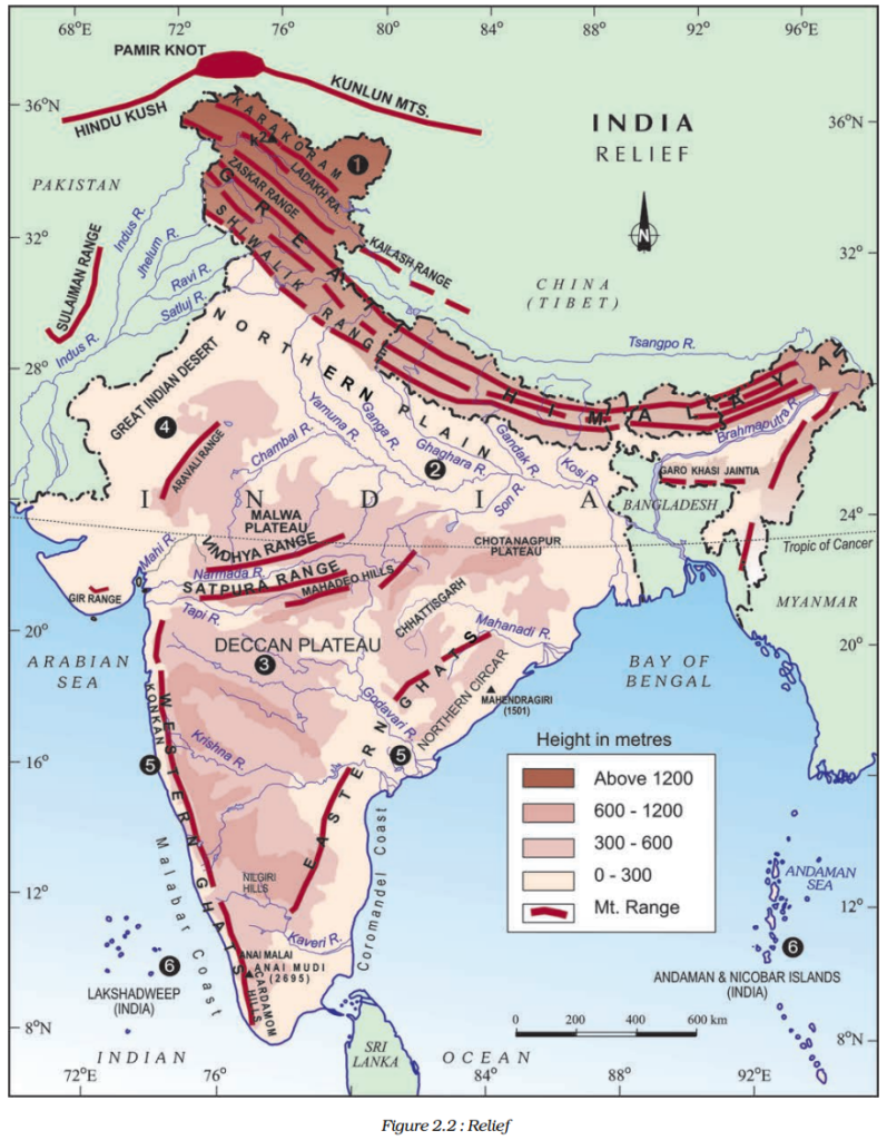
Major Physiographic Divisions
The physical features of India can be grouped under the following physiographic divisions (Figure 2.2):
(1) The Himalayan Mountains
(2) The Northern Plains
(3) The Peninsular Plateau
(4) The Indian Desert
(5) The Coastal Plains
(6) The Islands
1. The Himalayan Mountains
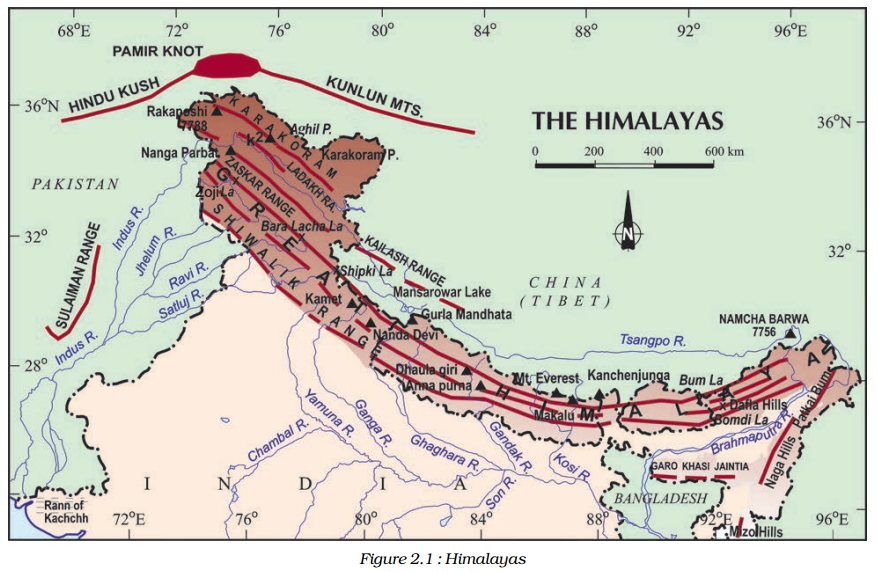
Introduction
- Geologically young and structurally fold mountains.
- Stretch over the northern borders of India.
- Among the world’s loftiest and most rugged mountain barriers.
Geographic Extent
- Run from the Indus to the Brahmaputra in a west-east direction.
- Arc-shaped, covering approximately 2,400 Km.
- Width varies from 400 Km in Kashmir to 150 Km in Arunachal Pradesh.
- Greater altitudinal variations in the eastern half.
Longitudinal Division of the Himalayan Ranges
1. Great Himalayas (Himadri)
- Northern-most range.
- Loftiest peaks with an average height of 6,000 meters.
- Composed of granite.
- Perennially snow-bound with numerous glaciers.
2. Lesser Himalaya (Himachal)
- Lies south of the Himadri.
- Most rugged mountain system.
- Composed of highly compressed and altered rocks.
- Altitude ranges between 3,700 and 4,500 meters.
- Home to the Pir Panjal, Dhaula Dhar, and Mahabharat ranges.
- Famous valleys include Kashmir, Kangra, and Kullu.
3. Shiwaliks
- Outer-most range of the Himalayas.
- Width: 10-50 Km.
- Altitude varies between 900 and 1,100 meters.
- Composed of unconsolidated sediments from the main Himalayan ranges.
- Covered with thick gravel and alluvium.
- Longitudinal valleys between Lesser Himalaya and Shiwaliks are known as Duns (e.g., Dehra Dun, Kotli Dun, Patli Dun).
Regional Divisions of Himalayas
- Himalayas divided into regions based on river valleys.
- West to east divisions:
- Punjab Himalaya (between Indus and Satluj).
- Kashmir Himalaya (also known as Himachal Himalaya).
- Kumaon Himalayas (between Satluj and Kali rivers).
- Nepal Himalayas (between Kali and Teesta rivers).
- Assam Himalayas (between Teesta and Dihang rivers).
Eastern Extension of Himalayas
- Brahmaputra marks the eastern-most boundary of the Himalayas.
- Beyond the Dihang gorge, the Himalayas turn southward, becoming the Purvachal or Eastern hills and mountains.
- Located in the northeastern states.
- Composed mainly of sedimentary rocks, particularly sandstones.
- Covered with dense forests.
- Includes the Patkai hills, Naga hills, Manipur hills, and Mizo hills.
2. The Northern Plain
Formation and Characteristics
- Formed by the interplay of three major river systems: Indus, Ganga, and Brahmaputra, along with their tributaries.
- Composed of alluvial soil.
- Deposition of alluvium over millions of years in a vast basin at the foothills of the Himalayas.
- Extends over an area of 7 lakh sq. km.
- Approximately 2400 km long and 240 to 320 km wide.
- Densely populated region.
- Fertile soil, ample water supply, and favourable climate make it agriculturally productive.
River Action
- Rivers from northern mountains involved in depositional work.
- Lower course characterized by a gentle slope, resulting in the formation of riverine islands.
- Rivers split into numerous channels (distributaries) due to silt deposition.
Division of The Northern Plain into Three Sections
Punjab Plains
- Located in the western part of the Northern Plain.
- Dominated by the Indus and its tributaries (Jhelum, Chenab, Ravi, Beas, and Satluj).
- Doabs are prominent in this section.
Ganga Plain
- Extends between Ghaggar and Teesta rivers.
- Spreads over North India, including Haryana, Delhi, U.P., Bihar, parts of Jharkhand, and West Bengal.
Brahmaputra Plain
- Found in the east, particularly in Assam.
Diverse Relief Features
- Contrary to the perception of flat land, the Northern Plains exhibit diverse relief features, categorized into four regions:
a. Bhabar
- A narrow belt (8 to 16 km in width) parallel to the Shiwalik slopes.
- Rivers deposit pebbles in this area.
- Streams disappear in the bhabar belt.
b. Terai
- Lies south of the bhabar belt.
- Characterized by wet, swampy, and marshy terrain.
- Originally thickly forested with abundant wildlife.
- Forests cleared for agriculture and settlement.
c. Bhangar
- The largest part of the northern plain.
- Located above the floodplains of rivers.
- Presents a terrace-like feature.
- Soil contains calcareous deposits known as kankar.
d. Khadar
- Younger deposits of the floodplains.
- Renewed almost every year.
- Fertile soil, ideal for intensive agriculture.
The Northern Plain, with its unique combination of fertile soil, river systems, and varied relief features, plays a crucial role in India’s agriculture and economy.
3. The Peninsular Plateau
Formation and Composition
- A tableland composed of old crystalline, igneous, and metamorphic rocks.
- Formed due to the breaking and drifting of the Gondwana land.
- Part of the oldest landmass.
Divisions
Two main divisions: Central Highlands and Deccan Plateau.
a. Central Highlands
- Lies to the north of the Narmada river.
- Includes the Malwa plateau.
- Bounded by the Satpura range in the south and the Aravalis in the northwest.
- Gradually merges with the sandy and rocky desert of Rajasthan in the west.
- Rivers like Chambal, Sind, Betwa, and Ken flow from southwest to northeast, indicating the slope.
- Wider in the west, narrower in the east.
- Eastern extensions are known as Bundelkhand and Baghelkhand.
- Further eastward is the Chotanagpur plateau, drained by the Damodar river.
b. Deccan Plateau
- Lies to the south of the Narmada river.
- Flanked by the Satpura range in the north.
- Slopes gently eastwards.
- Northeastern extension includes the Meghalaya, Karbi-Anglong Plateau, and North Cachar Hills, separated by a fault from the Chotanagpur Plateau.
- Prominent hill ranges in the northeast: Garo, Khasi, and Jaintia Hills.
Western & Eastern Ghats
- Western Ghats mark the western edge of the Deccan Plateau.
- Eastern Ghats mark the eastern edge.
- Western Ghats are continuous and higher than the Eastern Ghats.
- Western Ghats cause orographic rain by forcing moist winds to rise along their western slopes.
- Eastern Ghats are discontinuous, irregular, and dissected by rivers draining into the Bay of Bengal.
- Distinct local names for different sections of the Western Ghats.
- Notable peaks: Anai Mudi and Doda Betta in the Western Ghats; Mahendragiri in the Eastern Ghats.
- Shevroy Hills and Javadi Hills are located southeast of the Eastern Ghats.
- Famous hill stations include Ooty and Kodaikanal.
Deccan Trap
- Black soil area of volcanic origin.
- Rocks have denuded over time, resulting in the formation of black soil.
Aravali Hills
- Located on the western and northwestern margins of the Peninsular plateau.
- Highly eroded and broken hills.
- Extend from Gujarat to Delhi in a southwest-northeast direction.
The Peninsular Plateau, characterized by its ancient rocks, diverse relief features, and unique soil formations, contributes significantly to the geographical diversity of India.
4. The Indian Desert
Location and Characteristics
- Located in the western margins of the Aravali Hills.
- An undulating sandy plain with extensive sand dunes.
- Receives very low rainfall, typically below 150 mm per year.
- Arid climate with sparse vegetation.
- Seasonal streams appear during the rainy season but often disappear into the sand as they lack sufficient water to reach the sea.
Major River
- Luni is the primary and largest river in the region.
Types of Sand Dunes
- Barchans (Crescent-Shaped Dunes)
- Cover larger areas in the desert.
- Crescent-shaped formations.
- Prominent in some regions, especially near the Indo-Pakistan boundary.
- Can be observed in places like Jaisalmer.
The Indian Desert, with its arid landscape and distinctive sand dunes, is a challenging environment characterized by low rainfall and limited vegetation. The region’s unique geography and desert features contribute to its distinctiveness within India.
5. The Coastal Plains
Western Coast
- Flanks the Peninsular plateau.
- Lies between the Western Ghats and the Arabian Sea.
- Comprises three sections:
- Konkan Coast
- Northern part (Mumbai to Goa).
- Kannad Plain
- Central stretch.
- Malabar Coast
- Southern stretch.
Eastern Coast
- Runs along the Bay of Bengal.
- Features wide and level plains.
- Divided into two parts:
- Northern Circar
- Northern section.
- Coromandel Coast
- Southern section.
- Major rivers (Mahanadi, Godavari, Krishna, and Kaveri) have formed extensive deltas along this coast.
- Notable feature: Lake Chilika, located along the eastern coast.
The coastal plains, both on the western and eastern sides of the Peninsular plateau, offer diverse landscapes and are influenced by their proximity to the Arabian Sea and the Bay of Bengal, respectively. The presence of deltas and natural features like Lake Chilika enhances their significance.
6. The Islands of India
Lakshadweep Islands
- Located close to the Malabar coast of Kerala.
- Composed of small coral islands.
- Formerly known as Laccadive, Minicoy, and Amindive Islands.
- Renamed Lakshadweep in 1973.
- Cover a small area of 32 sq km.
- Administrative headquarters: Kavaratti island.
- Rich diversity of flora and fauna.
- Uninhabited Pitti island hosts a bird sanctuary.
Andaman and Nicobar Islands
- An elongated chain of islands in the Bay of Bengal, extending from north to south.
- Larger in size and more numerous compared to Lakshadweep.
- Divided into two broad categories: Andaman (north) and Nicobar (south) Islands.
- Believed to be an elevated portion of submarine mountains.
- Of great strategic importance for India.
- Abundance of diverse flora and fauna.
- Proximity to the equator results in an equatorial climate.
- Covered by thick forests.
The islands of India, including Lakshadweep and the Andaman and Nicobar Islands, offer unique ecosystems, rich biodiversity, and are strategically significant. They contribute to the country’s natural heritage and hold importance both ecologically and strategically.
Conclusion:
The diverse physiographic units of India, each with its unique features, play a crucial role in complementing one another and enriching the country’s natural resources. Here’s a detailed account of the significance of each region:
Mountains:
- The Himalayan Mountains, with their vast glaciers and high peaks, serve as major sources of water for rivers that flow into the plains.
- They are home to rich forest resources, contributing to biodiversity and providing habitat for various flora and fauna.
- The Himalayas also play a vital role in tourism and adventure sports, boosting the economy.
Northern Plains:
- Known as the “granaries of the country,” the northern plains have fertile alluvial soil, making them highly productive for agriculture.
- These plains are the heart of India’s agricultural sector, producing a significant portion of the nation’s food crops.
- The region’s extensive river network facilitates irrigation and transportation, further contributing to agricultural and economic growth.
- The plains also served as the cradle of early civilizations, such as the Indus Valley Civilization.
Plateau:
- The Peninsular Plateau is a rich storehouse of minerals, including coal, iron ore, bauxite, and limestone.
- These mineral resources have played a pivotal role in the industrialization and economic development of the country.
- The plateau’s topography and terrain also support agriculture and provide a foundation for many urban centres.
Coastal Regions and Island Groups:
- Coastal regions along the Arabian Sea and the Bay of Bengal offer extensive opportunities for fishing and port activities.
- These regions facilitate trade and commerce, making them crucial for economic growth.
- The Lakshadweep and Andaman and Nicobar Islands not only enhance the country’s marine resources but also contribute to tourism and ecological diversity.
In conclusion, the diverse physical features of India’s landscape offer immense possibilities for future development. These regions are interdependent, with each one contributing to the country’s overall growth and prosperity. The mountains provide water and forest resources, the plains are the agricultural backbone, the plateau offers minerals for industrialization, and the coastal regions and islands support trade, fisheries, and tourism. India’s geographic diversity is indeed a valuable asset for its continued development and sustainability.